

Bedminster Township was chartered in the name of King George II on April 4, 1749, the same day as neighboring Bridgewater Township. Both Bedminster and Bridgewater were carved from the Northern Precinct of Somerset County and named after towns in Somerset County, England. Bedminster retained its original territory until the secession of Peapack-Gladstone in 1912.
Settlement began in the 1690s and increased after the proprietors of East Jersey issued the Peapack Patent of 1701 to George Willocks and John Johnstone. In 1708, a deed from eleven Indians to European settlers mentions Indian town of “Peapock” in the northeast section of the township. Around 1739, a Presbyterian church was established in Lamington. Also in the early 1700s, refugees from the German Palatinate settled in the Pluckemin area and established a Lutheran church.
During the Revolution, Washington’s army marched through Bedminster after the battle of Princeton on their way to winter quarters at Jockey Hollow. During 1778-1779, Pluckemin was the site of the Artillery School commanded by General Henry Knox from his headquarters at the Vandeveer House, now a museum.
A railroad ran through Bedminster from 1889 to 1912 when the Rockaway Valley Railroad ran passenger and freight service from Whitehouse to Pottersville to Peapack. This connected the township to the New Jersey Central Railroad. Local peaches, as well as grain, lime, and milk were among the products shipped out of the area.
In the 20th century, Bedminster attracted many of America’s wealthy families who established large estates. Among the prominent names were James Cox Brady, Malcolm Forbes, and New Jersey Governor Thomas H. Kean. In 2002, future president Donald Trump bought the Lamington Farm estate from automaker John DeLorean.
During the 1960s, the construction of interstates 287 and 78 opened the township to increased commercial and residential development.
The New Jersey Supreme Court’s Mt. Laurel Decisions (1975 and 1983) on affordable housing resulted in the creation of the Hills Development and a large influx of new residents. In 1990, the census population of Bedminster soared to 7,086 from the 2,469 recorded in the 1980 Census—an increase of 187%. Most of the growth was caused by the opening of the Hills Development.
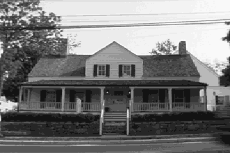
The Township has three historic districts, Lamington, Pluckemin, and Pottersville. There are four sites on the National Register of Historic Places: McDonald’s/Klines’s Mills, the Jacobus Vanderveer House, and the Hamilton Farm Stable Complex, which is home to the U.S. Equestrian Team.
According to the 2020 U.S. Census, the population of Bedminster Township was 8,272.
Bernards Township was created on May 24, 1760 by a charter issued by New Jersey’s colonial governor Sir Francis Bernard in the name of George II of Great Britain. Bernard named the township Bernardston after himself, and the name was subsequently shortened to Bernards. Bernards Township was the third township carved from the area known as the Northern Precinct of Somerset County—the previous being Bridgewater (1749) and Bedminster (1749). Originally, the township included what is now Warren Township, Far Hills, and Bernardsville. Warren Township seceded in 1806, followed by Far Hills (1921) and Bernardsville (1924).
The principal villages within the current boundaries are Basking Ridge and Liberty Corner. Minor villages include Madisonville and West Millington.
Basking Ridge and Liberty Corner were settled by Scottish and English settlers in the early 1700s. Refugees from the German Palatinate built a Lutheran Church around 1724 at southern edge of the township in what is now the Hills Development.
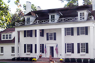
During the American Revolutionary War, American General Charles Lee was captured in Basking Ridge at Widow White’s Tavern (corner of South Finley & Colonial Drive) on December 12, 1776. Later in the war, Basking Ridge was on the supply route between Philadelphia and Washington’s army encamped at Jockey Hollow. The French Army marched through Basking Ridge and Liberty Corner on its way to Yorktown in 1781. William Alexander, Lord Stirling (1726-1783), an American general under George Washington, built a county estate on what is now Lord Stirling Road.
The New Jersey West Line railroad was extended to the township in 1872 with stations established at Lyons and Basking Ridge. Agriculture was long the principal industry throughout the township. Quarrying became a thriving business after the railroad provided efficient transportation for crushed stone.
In 1930, the VA Medical Center opened in Lyons. During the 1960s, the construction of interstates 287 and 78 opened the township to increased commercial and residential development.
The township has three historic districts: Franklin Corners, which is anchored by the Van Doren Mill; Liberty Corner; and the Lyons Veterans Administration Hospital. Other structures and sites on the National Register of Historic Places are: the Alward Farmhouse, Basking Ridge Presbyterian Church, Brick Academy, Boudinot Southard Ross Estate, Coffee House (Madisonville), Kennedy Martin Stelle Farmstead, Lord Stirling Manor Site, and Lyons Railroad Station.
According to the 2020 U.S. Census the population of Bernards Township was 27,830.
Originally called Vealtown, Bernardsville began as an unincorporated village within Bernards Township. During the Revolutionary War, the village was along the route of colonial troops and supplies headed to and from Morristown. In the winter of 1779-80, the New Jersey Brigade, consisting of 1,000 men and officers established an encampment in what is now Bernardsville along Hardscrabble Road. In 1840, Vealtown was renamed Bernardsville through the efforts of Roderick Mitchell, the local postmaster.
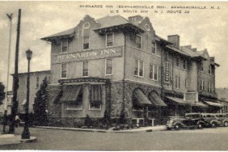
In 1872, the New Jersey West Line Railroad extended service to Bernardsville and spurred rapid growth. The area soon attracted wealthy businessmen, who established grand estates on the “mountain” north of the village. These men included George I. Seney, Charles Pfizer, Percy R. Pyne, and Anthony R. Kuser.
In 1924, driven largely by the prospect of lower taxes, Bernardsville chose to break away from Bernards Township. The Borough of Bernardsville was incorporated by an act of the New Jersey Legislature on March 6, 1924. The act did not take effect until a majority of voters in the proposed new borough approved the action in a special election on April 29, 1924.
Bernardsville has four sites on the National Register of Historic Places: the John Parker Tavern, the Bernardsville Train Station, the Reynolds-Scherman House and the Olcott Historic District. The Cross Estate/NJ Brigade Site, part of Morristown National Historical Park is also located in Bernardsville.
According to the 2020 U.S. Census the population was 7,893.
Far Hills was long a part of Bernards Township, but the name is fairly recent. One story says that in 1887, Elizabeth Schley, wife of Grant B. Schley, observed the beautiful vista of the “far hills,” and the name stuck to the area, which at that time had no village. Her husband, Grant B. Schley (1845-1917) is considered the founder of Far Hills. With his brother Evander, Grant bought up much of the land and built a large estate called Froh-Heim near the Raritan River (currently Moorland Farms)
At the urging of Grant Schley, the railroad was extended to Far Hills and Gladstone in 1890. In 1899, Evander Schley and David Dumont, a local farmer, plotted out lots for Far Hill village around the railroad station.
Rising taxes led the 200 residents of Far Hills to separate from Bernards Township and to incorporate as a Borough. On May 12, 1921, in a local referendum, voters approved the incorporation.
Besides the Schleys, Far Hills was also the site of several notable estates including Cragwood, once owned by industrialist Charles Engelhard.
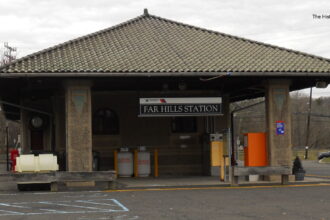
Far Hills has two sites on the National Register of Historic Places: the Far Hills Railroad Station and the Linn Homestead.
According to the 2020 U.S. Census, the population was 924.
The Leni Lenape tribe of Native Americans occupied the area of Peapack-Gladstone before European settlement. In 1701, the proprietors of East Jersey granted George Willocks and John Johnstone the “Peapack Patent”, which not only covered Peapack, but the entire area of Bedminster. A 1708 deed to settlers mentions an Indian village of “Peapock.” In the 18th and 19th centuries, the villages of Peapack and Gladstone developed an agricultural economy which included grain mills. Limestone quarries and kilns followed to supply the need for agricultural lime.
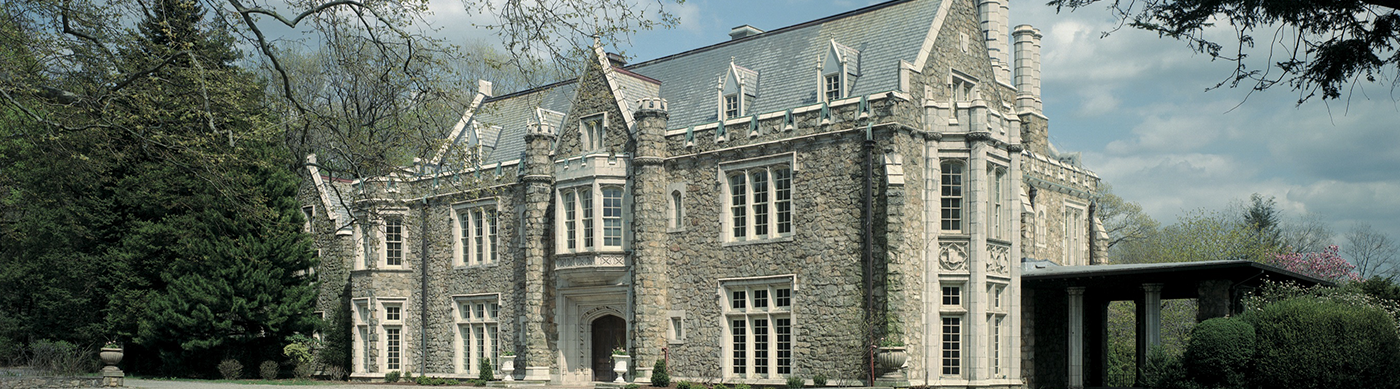
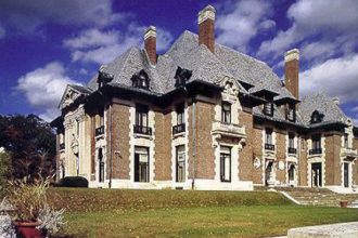
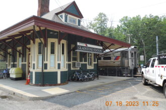
In 1890, two railroads reached the area. The Rockaway Valley Railroad reached Gladstone first from Whitehouse. The Rockaway ceased operation in 1913. Also in 1890, the Delaware, Lackawanna and Western (DL&W) railroad extended service from Bernardsville. Stations were built at both Peapack and Gladstone (the terminus). The arrival of the railroads, especially the DL&W, ushered in a new era as quarries, farms, and small industries could now ship products more efficiently. The railroad also led wealthy businessmen from New York City to establish large estates. Two are especially notable: Blairsden, completed in 1903 by C. Ledyard Blair, a New York banker, and Natirar (Raritan spelled backwards) built between 1910 and 1912 by Walter Graeme Ladd and his wife Kate Macy Ladd.
On June 6, 1912, Peapack and Gladstone were set off from Bedminster Township and incorporated as an independent twin borough.
Peapack and Gladstone has two sites on the National Register of Historic Places: The Moses Craig Lime Kilns and the Gladstone Train Station.
According to the 2020 U.S. Census, the population was 2,558.