
The 1766 map of Somerset County, NJ, by Benjamin Morgan and I. Hills shows many of the early landmarks and settlers of Bedminster Township. Bedminster at that time included the Borough of Peapack and Gladstone (created 1912).

The surveyors paid close attention to the rivers and mills, which were key transportation and economic features. The closeup of the northern section shows the Coxe grist mill on the Lemeton (Lamington) river south of what became Pottersville and Forman’s mill on Peapack Brook.
The southern section of Bedminster shows the mill of Andrew Leake, which after an unfortunate fire would become Burnt Mills (see THSSH Newsletter, Feb. 2023, p. 4). Pluckermin (Pluckemin) appears as the township’s principal settlement with a Dutch church. This was actually St. Paul’s Lutheran church which occupied the site of the current Pluckemin Presbyterian Church. The Bedminster Reformed Church at the site of the present Reformed cemetery is shown further north.
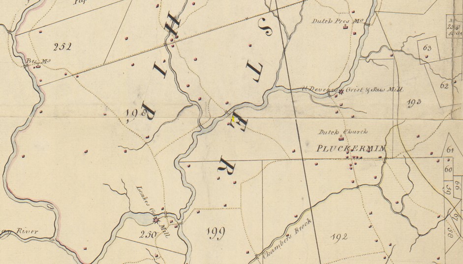
The surveyors identified landholders and their properties by lot number. In some cases, they provided the acreage. See table below;
Lot Name Acres
253 Andrew Hambleton (Hamilton) 875
254 Papack Patent
194 Alexander & Dunster 1240
250 George Willocks 60
200 Campbell & Blackwood 458
198 Daniel Extels (Axtell)
199 Ann West 912
192 Campbel & Blackwood 3970
193 Alexander & Dunster
62 John Pottengers 200
61 Alexander McDowell 64
60 Alexander & Dimster
66 Morris & Alexander
59 Benjam. Morgan
58 Samuel Nevill
Lot 254 is tagged as Papack Patent, a reference to the Peapack Patent of 1701 granted to George Willocks and John Johnstone. That patent once extended across most of the township. Many of names on the map were absentee owners who rented out their land to tenants and much of the information is clearly out-dated. George Willocks of Perth Amboy died in 1729. Alexander refers to James Alexander (1691-1756) of New York City, father of Lord Stirling. Note Benjamin Morgan, the surveyor, owned Lot 59.
Settlers known to be in Bedminster in 1766 like Johannes Moelich (Melick) are not named. Moelich’s farm, described in The Story of an Old Farm, was located near the confluence of Peapack Brook and the Raritan (around the “I” in Bedminster).
The full map of Somerset County can be found at: https://quod.lib.umich.edu/w/wcl1ic/x-586/wcl000691
See also: Bernards Township Landowners, 1766 for a discussion of land in Bernards Township from the same map.
Citation: “Plan of Somerset County in the province of New Jersey : Copied from the original by Lieut. I. Hills, asst. engr. / survey’d by Benjamin Morgan in 1766.” In the digital collection William L. Clements Library Image Bank. William L. Clements Library, University of Michigan Library Digital Collections. August 20, 2024.

I grew up outside of Pottersville, on what is now Union Grove Road. I’ve never seen so early a map of the area. How marvelous!
My Dow ancestors lived and farmed in the Pluckemin area in the early 19th Century and are buried in the old Dutch Reformed graveyard along 206 between there and Bedminster.