image_pdf

Somerset Hills Landmarks

Bedminster Township

Jacobus Vanderveer House

Also known as Knox House
Jct. of US 202 and 206, N of River Rd.,
Bedminster Twp., Pluckemin
(added 1995 – Building – #95001137)

Official Website – Click Here
Purchased by Bedminster Township in 1989 along with 218 acres, supported by the Friends of the Jacobus Vanderveer House and the Bedminster Historical Commission.

With its surrounding acreage, the Jacobus Vanderveer House is the last remaining site in Somerset County to have been associated with the locally prominent Vanderveer family. It is the only structure that remains intact from which to interpret the Vanderveer family and local Revolutionary War Activities.

While the period of historical significance is 1772, when the building was first built, the house reached its architectural apex in 1813, immediately following Mary Hardenburgh Vanderveers’ Federal style additions.

The Jacobus Vanderveer House is the last surviving building associated with the Vanderveers, a family prominent in Bedminster Township history from its earliest settlement through the 19th century.

General Henry Knox and his family lived in the house which served as his headquarters during the winter of 1778-79 while he was in command of the Continental Artillery. The c1772 Dutch American core of the Jacobus Vanderveer House is the only known extant building associated with the Pluckemin Encampment of 1778-79, which is considered to be the first installation in America to train officers in engineering and artillery.

The interior contains massive exposed beams as well as Federal, Greek Revival and Victorian woodwork. The house is owned by Bedminster Township and its restoration was completed in 2007.

Learn more about General Henry Knox, visit the Henry Knox Museum website

Lamington Historic District

Route 523.

National Register of Historic Places:     June 21, 1984 (Reference #: 84002802).

The  Lamington area was settled by 1740, but the historic district is made up of mostly 19th century buildings.  The Lamington district is primarily linear, stretching along Cowperthwaite Road, Route 523, and Rattlesnake Bridge Road, and consists of 10 houses, one store, one school, one church, and two cemeteries, all surrounded by open land.   The preeminent building is Lamington Presbyterian Church (built 1826, moved across the street in 1885).  Anthony’s Store (1895), the schoolhouse (1915) and the Andrew Leake House are also key contributing structures.

Lamington Presbyterian Cemetery contains many 18th-century gravestones including 35 for Revolutionary War veterans.   The Black Cemetery on Cowperthwaite Road was established in 1857 and contains the graves of many former slaves and members of Lamington’s once substantial black community.    

McDonalds/Kline's Mills, Klines Mill Road

Bedminster Township, New Jersey

A 19th -20th century “up and down” sawmill was listed on the National and New Jersey Registers of Historic Places in 1986. Privately owned by the estate of John Kean, a forebear of former Bedminster Township Mayor John Kean (and cousin of former New Jersey Governor Tom Kean, the mill is located on the North Branch of the Raritan River where Kline’s Mill Road intersected with River Road before a storm took the bridge out in April 1995. A sawmill is said to have operated on the site as early as 1744. An 1850 map shows the Widow Kline’s gristmill, sawmill and store. Three generations of Kline’s owned the mill. The mill has a field stone foundation , a one story board and batten exterior, and 15 pane single sash windows.

Source: (Booklet: Bedminster Township – 250 Years by Prich Matthews, page 21)

Pluckemin Village Historic District

Route 202-206 at Burnt Mills Road.

National Register of Historic Places:   7/26/1982 (Ref.#: 82003303).

Pluckemin Historic District was created in 1982 with 33 structures on approximately 43.5 acres.  The district is on both sides of Route 202-206 north of Burnt Mills Road, excluding the shopping center.  The buildings span around 100 years in construction date, but most are small 19th century houses.  The central focus is the Pluckemin Presbyterian Church (built 1851) and its historic graveyard.

Notable houses on the east side of Route 202-206 include the John Boylan House (“1751 House”),  the Strupp House (early 19th century), and the McKiernan House (early 19th century).  Along Burnt Mills Road, several structures on the north side and the 1912 schoolhouse/art center on the south side are included.

Pottersville Village Historic District

Route 512.

National Register of Historic Places:  August 20, 1990 (Reference #: 90001475).

The Pottersville Village Historic District sits along the Lamington River and includes parts of four townships in three counties.  Most of the district is in Bedminster, but parts extend into Tewkesbury, Hunterdon County, and Chester and Washington townships in Morris County.

Known earlier as Potters Mills, Pottersville was settled in the 1750s, and in the late 19th century was home to several industries including two flour mills, a sawmill, a foundry, and a basket factory.  The Rockaway Valley Railroad linked Pottersville with the Central Railroad of New Jersey at Whitehouse between 1889-1912.  The district retains the appearance of a rural village of the late 19th century to early 20th century.

The existing buildings date from 1850s to the 1920s, although some fragments of earlier structures may exist. The district contains 44 buildings, 2 structures, and 4 sites, all of which are classified as contributing.  The buildings are located on Black River, Pottersville, McCann Mill and Hacklebarney roads; Fairmount Road East; and Hill Street. 

Properties of major historic significance include the Reformed Church (1866), the former general store, the Upper Mill, and the site of the Lower Mill, which was demolished in 1972. 

Bernards Township

Alward Homestead

Commonly known as Chimney Ash Farm

40 Mount Airy Rd., Basking Ridge, NJ 07920

New Jersey State Register of Historic Places – 02/05/1986
National Register of Historic Places – 03/13/1986.

Currently sits on 1.5 acres of the original 150-acre farm and orchard. Built circa 1740, possibly originally inhabited by tenant farmers, Chimney Ash Farm portrays the simple and primitive lifestyle of many of New Jersey itinerant settlers.

The earliest northwestern three bay section was built circa 1740. An addition, in the third quarter of the 18th century, nearly doubled the size and provided simple embellishments (raised ceilings, beaded mantels), nevertheless the elemental nature of the home was retained.

Construction is of the post and beam type. The beams are notched and pegged. The original roof was of thick hand split shakes. Six fireplaces feed into two chimneys – one at each end of the house. There are seven rooms in all, in addition to a large fieldstone basement. Primitive wide pine floorboards are still present in two rooms and hand-hewn ceiling beams are visible throughout the first-floor rooms as well as in the ‘summer kitchen’ below. Ruins of external structures such as the stone foundation of the barn, a silo, and water well remain visible.

Henry Alward was born in 1761, one of eight children of Henry Alward III and Mary Cox. He married Osee Pennington, daughter of Johnathan Pennington and Osee Doty Pennington, in 1785. The newly married couple lived with her parents at their Stoney Hill farm in Basking Ridge.

At that time, Abraham Canfield of Morristown owned ‘Chimney Ash Farm’. He passed away in 1789 and the property was transferred to Jonathan Pennington who gifted the homestead to Osee and Henry. During the War of 1812, Henry left the farm to join the army. It is assumed that he lost his life in the battle of New Orleans in 1814. He is not laid to rest with his wife Osee and several of their children in the Basking Ridge Old Churchyard.

For nearly a century, three generations of the Alward family continued to live at Chimney Ash Farm. In 1872, Joseph, then the sole owner, sold it to Patrick Gougerty and the homestead passed out of family hands.

Basking Ridge Presbyterian Church

1 East Oak Street, Basking Ridge

National Register of Historic Places: 1974, Registration #74001190

The Basking Ridge Presbyterian Church, built in 1839, is a Greek revival brick building near the site of an earlier log church (c.1719) and wood-frame church (1749). The Presbyterian Church was long known for the huge 600+ year-old white oak that stood in its churchyard. The oak died and was removed in 2017. About 35 Revolutionary War soldiers are buried in the graveyard.

Visit the Presbyterian Church website for additional information including historic texts and cemetery records.

Boudinot Southard Ross Estate

(Pronounced Boo -Din-know)

Placed on the New Jersey and National Registers of Historic Places Sept. 11, 2009 and Dec. 18, 2009 respectively.

The fifty-acre Boudinot-Southard-Ross property, which borders the Basking Ridge Country Club and Lord Stirling Park, has three historic buildings: a house, barn, and outbuilding. The original house, which retains some early details, was built in 1777 by Elias Boudinot. The property is surrounded by preserved open space and offers wonderful panoramic views.

Brick Academy

15 West Oak Street
Basking Ridge section of
Bernards Township

Basking Ridge Classical School (added 1976 – Building – #76001185)
Also known as The Academy;The Brick Academy
Most Significant person: Robert Finley.

The 1809 Federal-style Brick Academy located in the center of Basking Ridge has been a boys’ private preparatory school, a public school, a meeting hall for several fraternal and benevolent organizations, and the Bernards Township municipal building. It currently serves as the headquarters of The Historical Society of the Somerset Hills. Learn more.

Coffee House c.1900
Coffee House 2023
2023 Excavation

Coffee House

North Maple Avenue, Basking Ridge, NJ 07920

New Jersey State Register of Historic Places – 3/28/1977

National Register of Historic Places – 11/7/1977 (Reference #: 77000906)

The Coffee House has been a focal point of the village of Madisonville for over 200 years.  On some old maps, the intersection at the corner of Madisonville Road and North Maple is called Coffee House Corner.  The oldest part of the Coffee House may date to as early as the 1780s and was perhaps moved to its current location.  The newer sections date to the 1870s.

In 1804, Daniel Doty purchased the property where he operated a store.  The 1806 Bernards Township tax records list Daniel Doty and his son-in-law Isaac Southard (1783-1850) as owners of the store.  In 1814, Jacob Burtt purchased the property and obtained a license to operate a tavern he called the Coffee House. Joseph Doty, Daniel’s son, bought the tavern in 1819 and maps show it as his residence in 1821-23.   The last known tavern keeper was Levi Clauson in 1828-29.

Owners in more recent years included Benjamin Albro and his daughter Lydia (1823-1905), the Dayton family, and Kenneth A. and Marjory L. Turner, Jr.  Kenneth Turner was president of the Basking Ridge Historical Society and was largely responsible for listing the building on national and state registers.  It is currently a private residence.

In 2023, stone foundations dating to as early as the 1780s were found on the property and were excavated by volunteers from Monmouth University.

Winner of the 2005 THSSH Historic Preservation Award.


Franklin Corners Historic District

(470 acres, 11 buildings)

Franklin Corners Historic District (added 1975 – District – #75001159)
N of Bernardsville on Hardscrabble and Childs Rds. and U.S. 202, Bernardsville

Samuel Johnson House
Van Dorn’s Mill,
Franklin Corner School

Kennedy Martin Stelle Farmstead

Kennedy–Martin–Stelle Farmstead (added 2004 – District – #03000868)
450 King George Rd., Bernards Township (Basking Ridge)

The historic Kennedy-Martin-Stelle Farmstead, a National Register site located at 450 King George Road in Bernards Township, is being preserved and operated by the Friends of the Kennedy-Martin-Stelle Farmstead, a separate organization from the Historical Society …more

Liberty Corner Historic District

(added 1991 – District – #91001477)- Also known as Liberty Corner
Roughly, jct. of Church St. and Valley and Lyons Rds., and area W and SW, Bernards Township, Liberty Corner

1722 – John Annin, officially know as John Johnston of Annandale, Scotland, arrives in Bernards and takes title to 1,000 acres. The settlement was known as Annin’s Corner.

In 1766, William Annin, son of John Annin, builds an old stone house with rocks from the neighboring quarry. There are initials on these blocks “W.A” and “H.S.M”, along with the date, indicating the Builder (William Annin) and the mason (Hugh Sunderland).

Sometime during American Revolution, the name is changed from Annin’s Corner to Liberty Corner. However, the area was also mentioned as Bullion’s Tavern during the war.

While the Annin stone house was destroyed, it was located just across from the present day English Farm, site of the Rochambeau Revolutionary trail through Liberty Corner (See Events), in August 1781, when the area was called Bullion’s Tavern (for the tavern that was located in the center of town). Additional Photos and maps are in the Photo archive section.

Lord Stirling’s House, Needlework by Katherine Wright, 1784

Lord Stirling Brick Outbuilding, 1977

Lord Stirling Manor Foundations

Lord Stirling Manor site

96 Lord Stirling Road, Basking Ridge, NJ

National Register of Historic Places: 05/22/1978, Reference # 78001795

Site of colonial mansion of William Alexander (1726-1783), also known as Lord Stirling, who began building the manor house in 1763 on a 700-acre estate. Lord Stirling was a Major General in the Continental Army during the Revolutionary War. After Stirling’s death, the building fell into disrepair and became known locally as “The Buildings.” Two subsequent houses were built on the manor’s foundations–the current one in the 1920s.

Existing remains include walls and a barrel vault in the current house’s cellar. Two brick outbuildings were once thought to be colonial slave quarters, but are now believed to be farm buildings built (c.1840) by the Barkalow family. The estate included most of what is now Lord Stirling Park. Somerset County conducted archaeological digs on the site from 1983 to 1991.

Lyons Train Station

Lyons Road

National Register of Historic Places: 1984 (Reference #: 84002805)

Rail service began at Lyons in 1872 when the New Jersey West Line Railroad was extended to Bernardsville. An early wood station burned in 1918 (see more).  For many years, a baggage car was used as a replacement. In 1931, prompted by the opening of the VA Hospital and electrification of the rail line, a new brick Tudor Revival-style structure was built. Designed by architect D. T. Mack, the station was the last built along the Gladstone branch.

Lyons Veterans Administration Hospital Historic District

151 Knollcroft Rd, Lyons, NJ 07939

National Register of Historic Places: July 17, 2013, Registration # 13000461

In 1928, the government purchased the Walter E. Reynolds estate, known as “Knollcroft” for $130,000 and construction of the hospital began the following year. The estate’s original stucco and brick mansion (c.1910), later known as “Manor House,” served as the hospital manager’s house and is now a private residence on Manor Drive.

The hospital was opened in 1930 as a neuropsychiatric hospital for veterans and was converted to a general hospital in 1976. When opened in 1930, the hospital included approximately 320 acres, which increased to 864 acres by the 1950s to accommodate agricultural areas for occupational therapy. Currently, the center occupies 303 acres, all of which are within the historic district.

Thirty-four structures, mostly buildings, are considered historically significant for the time period (1929-1950). The four-story Main Building is constructed in an elaborate Classical Revival style with a domed cupola and weathervane. Other structures include the Acute Building (1929), Tuberculosis Building (1930), and Neuropsychiatric Infirmary Building (1930). A golf course was constructed in 1947 as a therapeutic outlet for patients.

Bernardsville Borough

Bernardsville Train Station

U.S. Route 202

The top photo shows the original station built in 1872 in the Victorian Stick Style. At the time, it was the terminus of the NJ West Line Railroad which ran from Summit to Bernardsville. This wooden structure was moved around 1902 and is still standing at 17 Morristown Road (Route 202) where it was the long-time office of The Bernardsville News.

The bottom photo shows the current Richardsonian Romanesque stone station built in 1901-02. Designed by Bradford Gilbert, it was placed on the National Register of Historic Places in 1984 (Reference #: 84002786).

Image courtesy of Perkins Library, Duke University, Durham, North Carolina.

Recent image of the former Bernardsville Library

John Parker Tavern

The gray building that housed the Bernardsville Public Library for over ninety years was originally called the Vealtown Tavern and later the John Parker Tavern. Constructed in the 1700’s, the tavern was a stopover for the weary and thirsty, an inn for passersby, and, for a time, served the officers and men of the Continental Army, and lore tells of a ghost as well.

New Jersey Brigade Encampment

Morristown National Historical Park
Jockey Hollow Road, Bernardsville, NJ

Revolutionary war encampment used by the New Jersey Brigade of the Continental Army during the winter of 1779-80. Approximately 1,000 soldiers and officers wintered here in huts along the hillside above Hardscrabble Road. The site was excavated during the 1960s and subsequently added to Morristown National Historical Park. For more information, see the May 2022 newsletter.

Olcott Historic District

Olcott Avenue in Bernardsville, NJ

Olcott Avenue is named after Frederick Pepoon Olcott (1841-1909), a Bernardsville mountain colony resident who was president of the Central Trust Company in New York which later was merged with JP Morgan. Olcott owned a Bernardsville estate which included the area including the Somerset Hills Country Club.

In 1905 a local resident, Frederick P. Olcott bought twenty-seven acres of what was then known as the Wolfe tract of what is now Olcott Avenue for $10,000. He erected the present stone 9 room Olcott Building at a cost of approximately $100,000 and presented the property to the Bernards Township school district (Bernardsville was still part of Bernards Twp until 1924).

This building served as the first high school in Bernards Township and also housed Bernardsville’s elementary grades. That building was designed by architect Henry Janeway Hardenbergh. Hardenbergh also was the architect for the Plaza Hotel, the Waldorf Hotel and the Dakota Apartments in New York City, Lincoln said.

While the Olcott Avenue School is but one historic structure within Bernardsville’s first historic district area, the areas appeal and historic significance remembers the story of the rise of the middle class in Bernardsville and how this particular location impacted the entire region, from the downtown, Little Italy, and even the Mountain Colony areas.

Reynolds - Scherman House

71 Hardscrabble Rd, Bernardsville, NJ

National Register of Historic Places: March 15, 1989 (Reference # 89000298)

The structure was probably built in the mid-18th century either as a barn or storage facility. Local legend says it was used in the Revolutionary War as a commissary storehouse. It is notable that the site of the New Jersey Brigade encampment in 1779-80 is on the hillside to the north of the house. The first definite evidence of a structure on the site appears in a deed of 1801. In 1832, “Squire” Samuel Reynolds, who operated a fulling mill in the area, acquired the property. He converted the structure to a house with a center chimney and four fireplaces. The original layout consisted of a dining room and keeping room on the first floor and two bedrooms on the second floor. It is unknown when and if the third floor was completed at that time. The stonework around the front windows indicates that the openings were probably doors originally.

The house was subjected to neglect for long periods of time and early photographs show the absence of the pond due to a probable dam failure.

Harry Scherman (1887-1969), co-founder of Book of the Month Club, acquired the property in the early 1920s as a summer home and began the process of restoring it. There was a grist mill on the pond across Hardscrabble Rd which was razed and the stone used for the eastern addition to the house in the early 1940s adding a kitchen, breakfast room on the first floor, and living room and an additional fireplace on the second floor. A laundry room and bathroom on the first floor were also added then or subsequently.

Various owners have updated the facility since then adding air conditioning, updated electric service, plumbing, and crawl spaces.

Far Hills Borough

Alexander and James Linn Homestead

Mine Brook Road (U.S. Route 202)

National Register of Historic Places: 1988 (Reference # 88002057)

This wood-frame house was built (c.1750) by Alexander Linn and expanded by his son James. The associated farm at one time comprised several hundred acres. Alexander Linn (d. 1776) was a Somerset County judge. James Linn (1749-1821) was a major in the New Jersey militia during the Revolution and a U.S. Representative from New Jersey (1799-1801). Later owners included Daniel Whitenack.

Far Hills Train Station

U.S. Route 202.

The original Far Hills station (top) was built around 1895. The building was replaced in 1914 by the current concrete structure (bottom) designed by L. R. Simpson in the Renaissance Revival style. The 1914 station was listed on the National Register of Historic Places in 1984 (Ref # 84002789).

Peapack and Gladstone Borough

1701 - The "Peapack Patent" of 1701

1701 – The “Peapack Patent” of 1701 transferred lands from 24 proprietors of East Jersey to George Willocks and John Johnstone.

On June 6, 1912 Peapack and Gladstone set off from Bedminster Township and incorporates as an independent twin borough.

Gladstone Train station in 1908

Gladstone Train Station

Main Street

National Register Historic Places: 1984 (Reference # 84002792)

This wood Queen Anne-style building was erected in 1890 at the terminus of the Gladstone branch of the railroad. Scenes for the movie The Miracle Worker were filmed here in 1967 (See October 2021 newsletter).

Moses Craig lime Kilns

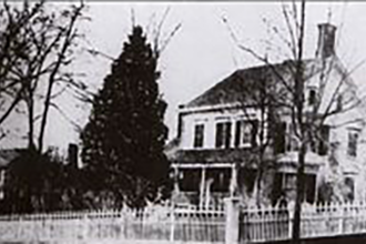
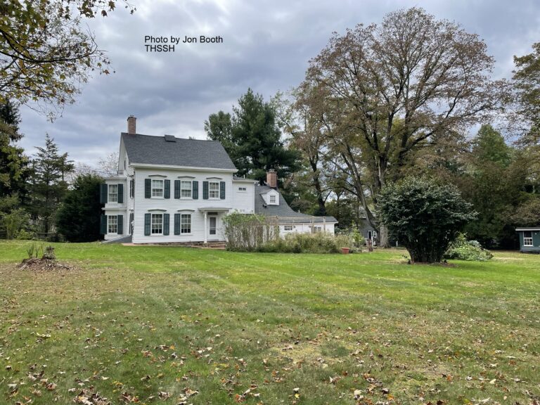
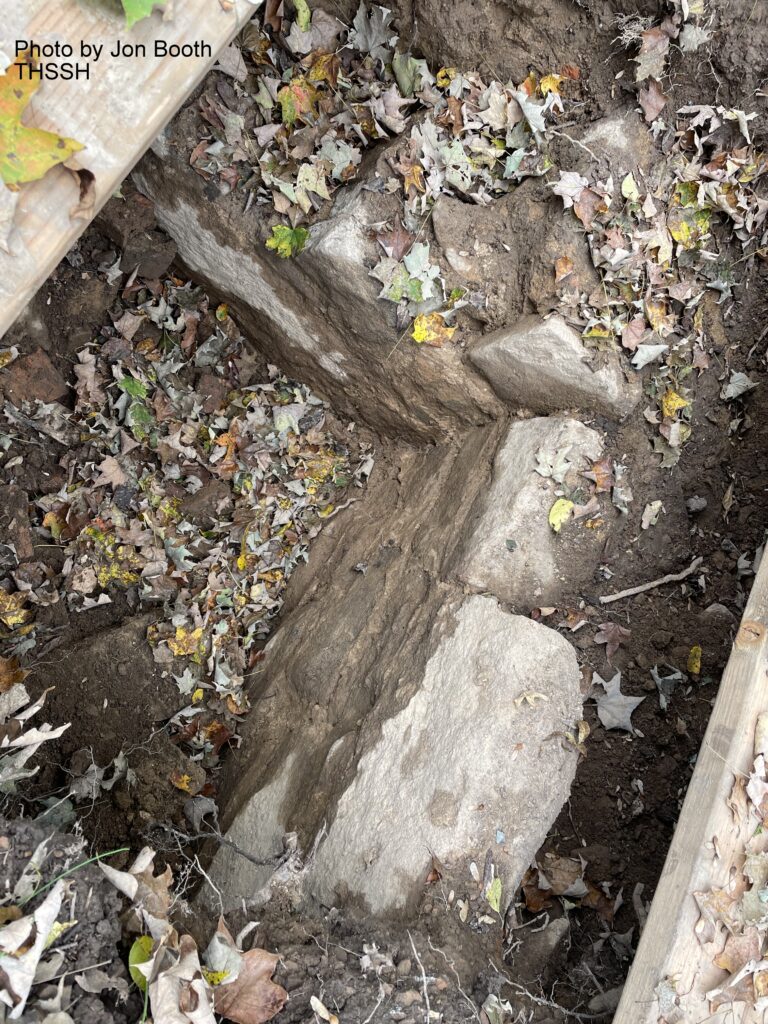
122 Main St., Peapack, NJ

National Register of Historic Places: Apr. 11, 2019 (Registration# 100003610)

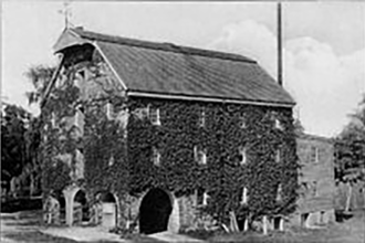
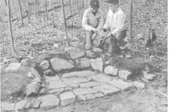
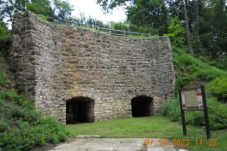
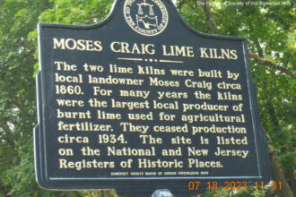
The Moses Craig Lime Kilns were built around 1860 and named after Moses Craig (1797-1874) who operated the kilns and a nearby limestone quarry. The kilns were donated to the The Historical Society of the Somerset Hills (THSSH) in 1998 when the adjacent property was being developed as a residential subdivision. THSSH created a pocket park featuring the kilns that was dedicated in May 1999 and opened to the public. In 2019, the THSSH transferred the property to the Borough of Peapack-Gladstone, which now maintains it as a public space. The preserved kilns serve as an important reminder of the agrarian heritage of the area.

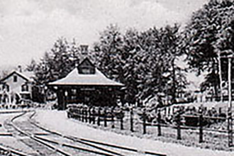
A lime kiln operation existed in Peapack as early as 1794. By that time agricultural land in New Jersey was “wearing out,” and an important use for lime was as a soil additive used by farmers to increase the yield of their crops. Many farmers burned limestone in small kilns on their property, but the Craig kiln was a commercial operation. Lime was also an important ingredient in mortar and whitewash. Lime would also have been used in the early leather-tanning factory that was located beside the Peapack River south of the kilns. An 1848 daybook kept by John Stelle, a farmer in southeast Bernards Township, records numerous trips to Peapack for lime during the winter months when roads were frozen or snow covered, making the 20-mile round trip wagon journey easier than during the warmer months when mud frequently made roads nearly impassable.

The Peapack area was a good source for limestone, which was quarried in the nearby vicinity well into the 20th century. The quarried limestone was loaded into the limekiln from the top, alternating with layers of fuel, such as charcoal early on and eventually coal. After burning for about 60 hours, the lime was removed from the bottom of the kiln.

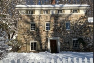
The Craig kiln is composed of two adjacent kilns separated by a vertical joint visible in the stone wall, which suggests they may have been constructed at different times. The front wall, constructed of hewn stone, is 26’ high and is set into the side of a hill that provided easy access to load the limestone and fuel from the top.

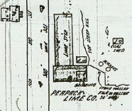
A Sanborn insurance map from 1932 shows the Peapack Lime Company operation,
with the two kilns labeled as “burners,” a nearby coal shed, a grinding room, and a large storage building.

Click Here for past news releases about the Moses Craig Lime Kilns