The collections listed below are housed at the Brick Academy. The Historical Society of the Somerset Hills (THSSH) continues to add to its document collection. If you would like to see our collections, please Contact Us to make arrangements.
Maps & Surveys
Images: Photos, Postcards, Slides
Scrapbooks
Books: Yearbooks, Ledgers, Minute Books, out of print books
Subject Files
Property Files
Local Family/Genealogy Files
Historical Society Files
Ephemera (paper artifacts)
Framed items
Oral histories
Special collections
Books
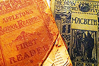
Original 1888 Brick Academy Student's School Books Come Home
Donated to THSSH by Michael Scheuereman, the great, great, great grandson of William Scheuereman, a Basking Ridge resident and Brick Academy student, two antique books by D. Appleton and Company of New York, printed 1888, came home to the Brick Academy! Take a step back in time and come see these great pieces of our local history.
Publications
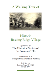
Walking Tour of Basking Ridge
A great way to see some of the most noted historical sites in and around the downtown Basking Ridge area.
Published 2004
Click below to view or download this booklet.
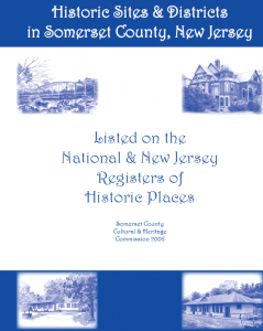
Somerset County
Historic Sites & Districts (2009)
A fantastic 59 page book including sketch drawings, town by town listings, and stories about all of the state and nationally registered historical assets in Somerset County, New Jersey.
Click below to view or download this booklet.
The History of the Presbyterian Church
The Presbyterian Church, Basking Ridge, NJ – A History 1717-1968 by Dorothy Loa McFadden, Mildred Van Dyke and Eileen Luz Johnston
Click below to view or download this booklet.
Cemetery Records from the Basking Ridge Presbyterian Church
Stories of Some Interesting People Buried in the Basking Ridge Presbyterian Cemetery by George Fricke
Click below to view or download this booklet.
Documents
The History of Bernards Township Street Names
Ever wonder why a street is named the way it is? Learn about the history of almost every street name in Bernards Township.
Click below to view or download this document.
A Town In Transition - Basking Ridge in 1940
In 2005, the Historical Society of the Somerset Hills was given a manuscript written by Basking Ridge resident Janet Carswell in 1940 when she was a college student.
Not only does the paper contains charming descriptions and views of the town as it was at that time, it also includes some fascinating analysis about the population by Ms. Carswell, along with some humorous vignettes.
The images are especially interesting, for they provide a visual snapshot of the village when it was just on the cusp of a period of unprecedented growth.
Stop by the historic Brick Academy to read this remarkable paper.
Bernardsville History
Historical Timeline 1723-1951
Click below to view or download this document.
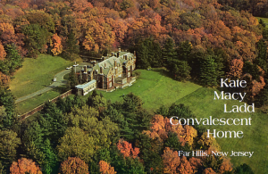
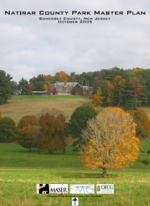
Kate Macy Ladd (Natirar)
Reproduced Brochure- Includes history, photographs and descriptions of the services and estate grounds.
Also, see what Somerset County is proposing as a master plan to preserve Natirar and the new Somerset County Park proposal.
Click below to view or download this booklet. (20 pages).
Natirar Master Plan
Also, see what Somerset County is proposing as a master plan to preserve Natirar and the new Somerset County Park proposal.
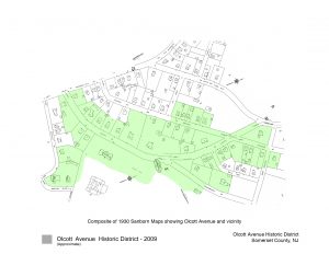
Olcott Avenue is named after Frederick Pepoon Olcott (1841-1909), a Bernardsville mountain colony resident who was president of the Central Trust Company in New York which later was merged with JP Morgan. Olcott owned a Bernardsville estate which included the area including the Somerset Hills Country Club.
View or download the complete Olcott Ave Historic Nomination Report
View or download the photographs/map/historic photos file (46mb)
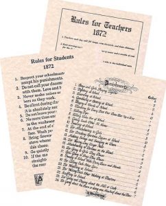
1872 Schoolhouse rules and Punishments
One of our favorite documents of punishments for both Teachers and Students back in the 1890s. For purchase at the THSSH bookstore.
Videos
Cemetery Walk through - 2012
Thirty five Revolutionary War Soldiers are buried in this cemetery:
Benjamin Alward John Ayres Nathaniel Ayres John Baird George Bockoven John Boylan John Brees Sr. John Brees Jr. Stephen Brees
John Carle Jonas Carle Hugh Colwell Daniel Doty William Doughty James Finley John Hall Samuel Johnson Alexander Kirkpatrick
David Kirkpatrick James Kirkpatrick Edward Lewis Thomas Logan Gavin McCoy Jonathan Miller John Parker Samuel Reynolds Israel Rickey
Thomas Riggs Peter Sharpenstine David Simpson Henry Southard James Thompson Jonathan Whitaker Sr. Jonathan Whitaker Jr. Stafford Wilson
Maps
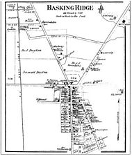
Map - Basking Ridge Village - 1873
From the Atlas of Somerset County, New Jersey, published by Beers, Comstock & Cline, 36 Vesey Street, New York, 1873.
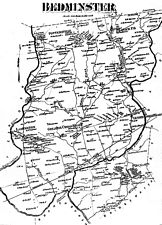
Map - Bedminster Township 1873
From the Atlas of Somerset County, New Jersey, published by Beers, Comstock & Cline, 36 Vesey Street, New York, 1873.
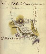
Map - Bullions Tavern aka Liberty Corner 1781
Courtesy of the Library of Congress.
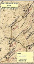
Map - Bullions Tavern aka Liberty Corner 1781
Courtesy of the Library of Congress
From the Volume set “The American Campaigns of Rochambeau’s Army 1780, 1781, 1782, 1783. Translated and Edited by Howard Rice and Anne Brown, Princeton University Press, Brown University Press, 1927
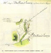
Map - Bullions Tavern aka Liberty Corner 1781
From the Volume set “The American Campaigns of Rochambeau’s Army 1780, 1781, 1782, 1783. Translated and Edited by Howard Rice and Anne Brown, Princeton University Press, Brown University Press, 1927
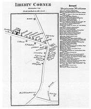
Map - Liberty Corner Village 1873
From the Atlas of Somerset County, New Jersey, published by Beers, Comstock & Cline, 36 Vesey Street, New York, 1873.
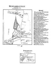
Map - Bernardsville & Madisonville 1873
From the Atlas of Somerset County, New Jersey, published by Beers, Comstock & Cline, 36 Vesey Street, New York, 1873.
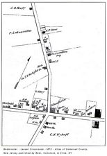
Map - Bedminster's Lesser Cross Road 1873
Bedminster 1873
From the Atlas of Somerset County, New Jersey, published by Beers, Comstock & Cline, 36 Vesey Street, New York, 1873.
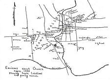
Map - Pleasant Valley c.1880
(W. Millington/Millington/Lyons-Bernards Township) what looks like the junction of Valley Road and Stonehouse Roads today (see Baptist Church icon)
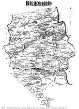
Map - Greater Bernards Township c.1875
From the Atlas of Somerset County, New Jersey, published by Beers, Comstock & Cline, 36 Vesey Street, New York, 1873.
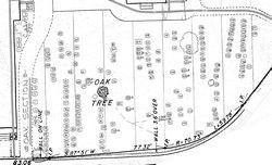
Map - Basking Ridge Presbyterian Church Graveyard
Basking Ridge Presbyterian Church Graveyard Map – Oak Tree Area
CementeryCemetery Burial Records/ Maps – Presbyterian Church, Basking Ridge
See if you have ancestors from the region. 700+ plot records!
Cemetery Records from the Basking Ridge Presbyterian Church
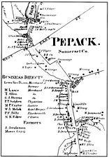
Map - Peapack Village c.1850
Then part of Bedminster.
From the Atlas of Somerset County, New Jersey, published by Beers, Comstock & Cline, 36 Vesey Street, New York, 1873.
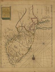
Map - Thortons of the East West Jersey Region c.1700
John Thornton’s massive atlas of maritime charts covering the entire nautical world. On this copper-engraved early English nautical chart includes soundings in New York harbor, Delaware Bay, and off shore. The diagonal lines are early colonial boundaries. The beautiful hand-colored outline and wash coloring is original.
North and South New Jersey (or East and West Jersey in colonial times) have always differed in some respect—geographically, politically. The northern areas were settled by the Dutch, and had a commercial focus strongly oriented toward the New York City market. The southern part of the state was settled by Swedes along the Delaware, and was a more rural farm-based economy linked to Philadelphia markets. The Dutch eventually took over the Swedish colonies, and those were subsequently taken by the English. The royal province of New Jersey was established by the English in 1702. During the American Revolution, New Jersey was a crossroads of conflict.
Research References
Moguls, Millionaires, Statesmen, Captains of Industry, Financial Giants, Media People, Society Figures, Politicos known about the Somerset Hills Area
From the archives of Inside the Brick Academy – September 2002 Throughout the year, distinguished residents who live/lived in the Somerset Hills will be listed. Then, as now, the area’s serene beauty and wholesome life style have attracted the rich, famous, and outstanding people. – Click Here
New Jersey Digital Highway
The New Jersey Digital Highway is a statewide portal to the digital collections of the state’s libraries, museums, archives, historical societies and other cultural heritage organizations. Books, manuscripts, newspapers, and other print materials, photographs, audio/video media, maps, and images of three-dimensional objects are all included.
New Jersey Digital Highway is hosted by the Rutgers University Libraries on behalf of the participating cultural heritage organizations.
Click below to access THSSH’s digital collection.
AT & T - A Crack in the Bedrock
NY Times January 14, 1996 – Part of the Downsizing of America Series and what it meant to Basking Ridge and the rest of the Somerset Hills – Click Here
THSSH seeks to promote education and appreciation for the value of historical documents and materials through public use of its collections, including images, manuscripts, maps, ephemera, etc. Access to the archives is provided to all researchers on an equal basis. Reproduction and use of items from our collections is subject to the following general guidelines and to the U.S. Copyright Law, which governs the use of copyrights material. Allowing the use of materials or supplying a “fair use” copy is not an authorization to publish. Learn more.